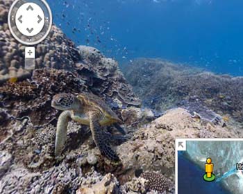
Google adds first underwater panoramic images to Google Maps
 Making a truly remarkable addition to its Google Maps feature, Internet search giant Google has brought on the first underwater panoramic images, giving the users an unparallel opportunity to explore as well as experience six incredible living coral reefs, without having to actually dive into the ocean.
The superlative coral reef images introduced to Google Maps were captured for the company's Street View service; and were an outcome of Google's collaboration with The Catlin Seaview Survey, which is one of the foremost scientific studies of the reefs around the world.
The coral reef panaromas which Google has added to its Maps service include Australia's Great Barrier Reef near Heron Island, Lady Elliot Island and Wilson Island; and also the Hanauma Bay and Molokini Crater in Hawaii; and the Philippines Apo Island.
According to the information shared by Brian McClendon - Google's VP of Google Maps and Earth -, the underwater images of the reefs were captured with the help of a specially-designed underwater camera, the SVII. About the special camera, The Catlin Seaview Survey said that the device is capable of capturing rapid-fire 360 degree photos every three seconds while moving at a 4kmph speed.
Terming the images as "vibrant and stunning," McClendon said that the addition of the coral reef pictures to Google Maps marks the "next step" for Google, in the company's "quest to provide people with the most comprehensive, accurate, and usable map of the world."